Severe Storms and Flooding Alert: Nature’s Fury Unleashed!
Active Weather Pattern Forecast: Showers and Thunderstorms Expected
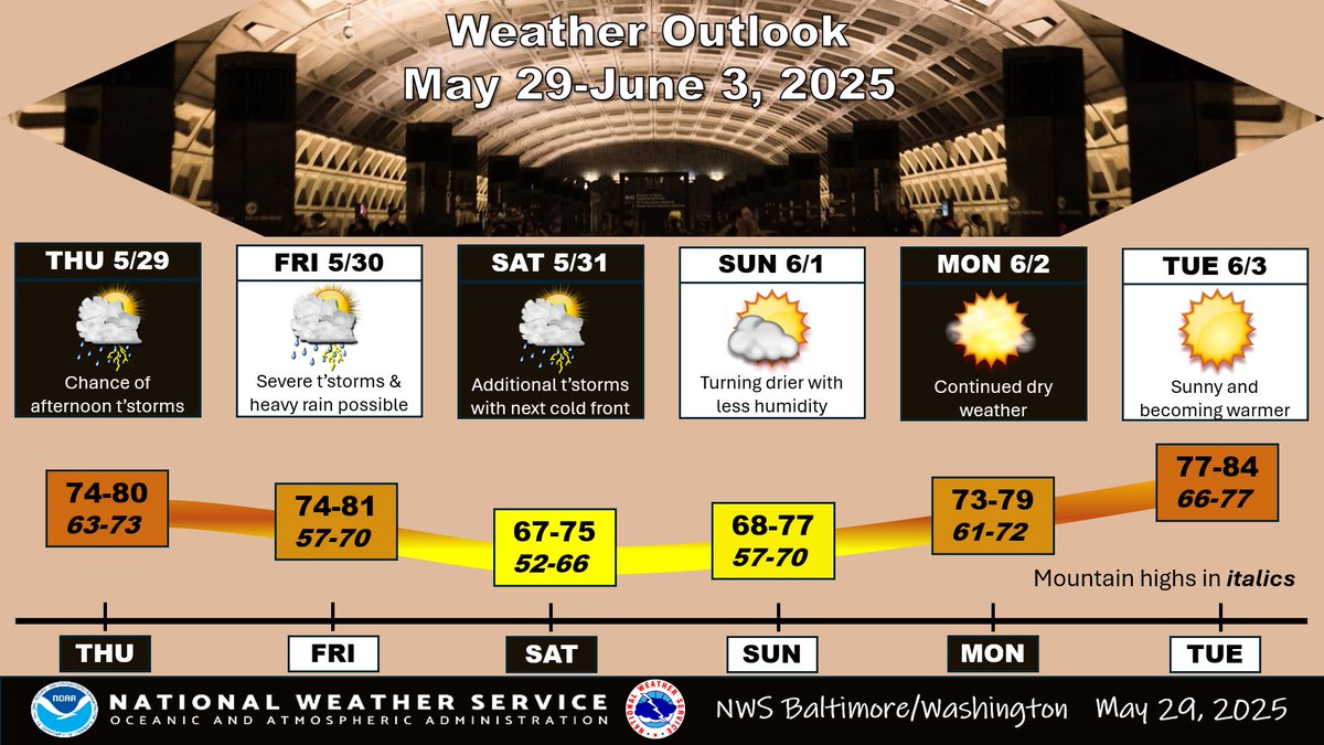
The National Weather Service (NWS) Baltimore-Washington has issued a weather update, indicating an active weather pattern that will persist from today through Saturday. This forecast includes daily showers and thunderstorms, with the potential for strong to severe storms and flooding, particularly on Friday. Following this active weather, conditions are expected to dry out and cool down by Saturday night, leading into a more stable dry period on Sunday and lasting into early next week.
Understanding the Weather Pattern
Weather patterns are influenced by various atmospheric conditions, including temperature, humidity, and pressure systems. The current forecast indicates a series of disturbances that will bring moisture-laden air into the region, resulting in the formation of showers and thunderstorms. These weather phenomena are common during transitional seasons like spring, where warmer air can clash with cooler air masses, creating instability in the atmosphere.

Daily Forecast Breakdown
- Today (Thursday): Expect the onset of showers and thunderstorms throughout the day. Meteorological conditions suggest that these storms may develop during the afternoon and evening hours, which is typical for convective activity. Residents should be prepared for localized heavy rainfall and potential lightning.
- Friday: This day is anticipated to be the most severe, with strong thunderstorms expected to develop. The NWS warns that these storms could reach severe levels, bringing the risk of damaging winds, hail, and flash flooding. Residents should remain vigilant and stay informed through local weather updates, especially if they have outdoor plans or travel scheduled.
- Saturday: As the system begins to move out of the area, conditions will start to cool and dry up. The forecast indicates a significant decrease in precipitation, with the possibility of lingering clouds in the morning. By Saturday night, residents can expect clearer skies as the atmosphere stabilizes.
- Sunday and Early Next Week: A marked improvement in weather conditions is expected. Dry and cooler weather will dominate the forecast, providing a welcome reprieve from the recent storms. This trend is likely to continue into early next week, making it an excellent time for outdoor activities and events.
Preparing for Severe Weather
With the potential for severe weather, it is crucial for residents in the affected areas to take the necessary precautions. Here are some tips to ensure safety during thunderstorms and possible flooding:
- YOU MAY ALSO LIKE TO WATCH THIS TRENDING STORY ON YOUTUBE. Waverly Hills Hospital's Horror Story: The Most Haunted Room 502
- Stay Informed: Keep up with the latest weather updates from trusted sources like the National Weather Service. Utilize weather apps and local news for real-time information.
- Prepare an Emergency Kit: Have an emergency kit ready, including flashlights, batteries, non-perishable food, water, and first-aid supplies. This kit can be vital in case of power outages or if you need to evacuate.
- Avoid Flooded Areas: Never attempt to drive through flooded roads. Flash flooding can occur quickly, and even a small amount of moving water can be dangerous.
- Secure Outdoor Items: If severe storms are expected, secure or bring indoors any outdoor furniture, decorations, or equipment that could be blown away or damaged by high winds.
Conclusion
The active weather pattern forecasted by the NWS Baltimore-Washington presents both opportunities and challenges for residents in the affected areas. While the showers and thunderstorms may bring much-needed moisture to the region, they also come with the risks of severe weather and flooding. By staying informed and prepared, individuals can navigate these conditions safely. As the weather stabilizes into the weekend, it will offer a chance for relaxation and outdoor activities, making the most of the improved conditions. Keep an eye on local forecasts, and enjoy the transition into drier weather.

An active weather pattern continues today through Saturday, with showers and thunderstorms in the forecast each day. Strong to severe storms and flooding are possible on Friday. Conditions dry out and cool down Saturday night. Dry conditions Sunday into early next week. pic.twitter.com/HYl0qh4dkI
— NWS Baltimore-Washington (@NWS_BaltWash) May 29, 2025
An Active Weather Pattern Continues Today Through Saturday
If you’ve been keeping an eye on the weather lately, you might have noticed that an active weather pattern continues today through Saturday. It’s that time of year when showers and thunderstorms are popping up in the forecast each day, so grab your umbrella and get ready for some rain!
The excitement of a summer storm can be invigorating, but it’s essential to stay informed about what’s coming your way. According to the [National Weather Service](https://www.weather.gov), the active weather pattern is likely to bring a mix of strong to severe storms, especially on Friday. This is the type of weather that can lead to some pretty wild skies and maybe even a little bit of thunder.
Showers and Thunderstorms in the Forecast Each Day
When we say showers and thunderstorms are in the forecast each day, we mean it! The weather is set to be quite dynamic, with moisture building up in the atmosphere. This means that every day could bring a chance for rain and those exciting summer storms.
It’s fascinating how nature works; warm air rising and cool air sinking creates instability in the atmosphere. This instability is what fuels those thunderstorms. So, if you’re planning to head out, don’t forget to check the latest updates. The [Weather Channel](https://weather.com) is a great resource for real-time information.
Strong to Severe Storms and Flooding Are Possible on Friday
Now, let’s talk about Friday. The National Weather Service has indicated that strong to severe storms and flooding are possible. This is not just your typical rain shower; we’re talking about storms that could bring heavy downpours, gusty winds, and maybe even hail.
Flooding can occur quickly, especially in areas with poor drainage, so it’s wise to be cautious. If you’re out and about, keep an eye on the skies and be prepared to take cover if necessary. Remember, when thunder roars, go indoors! You can follow updates from the [National Weather Service](https://www.weather.gov) to stay informed on severe weather alerts.
Conditions Dry Out and Cool Down Saturday Night
Now, after all this rain and stormy weather, there’s good news! Conditions are expected to dry out and cool down Saturday night. Just think about it: after a hot, humid week punctuated by storms, a cool evening is just what you need to reset and recharge.
This transition from stormy weather to a calm evening can be a relief. It’s a perfect time to step outside, enjoy the fresh air, and appreciate the beauty of a clear night sky. Make sure to take a moment to soak it all in because after the storms, the air tends to feel crisp and refreshing.
Dry Conditions Sunday into Early Next Week
As we look ahead to Sunday and into early next week, dry conditions are expected to settle in. What a pleasant way to wrap up the week! After all the rain, it’s nice to have some sunshine and dry weather to enjoy.
This is a great opportunity to get outside, maybe go for a hike, or have a picnic in the park. Whether you’re gardening, biking, or just relaxing in your backyard, make the most of the lovely weather.
For those who might be planning activities during this dry spell, it’s always a good idea to check the weather forecasts for any changes. You can find reliable updates on platforms like [AccuWeather](https://www.accuweather.com), which offers detailed forecasts and radar images.
Stay Prepared and Stay Safe
As we navigate through this active weather pattern, staying prepared is key. Here are a few tips to help you stay safe during potential storms:
1. **Keep an Eye on Weather Alerts**: Use weather apps or websites to track real-time updates. The [National Weather Service](https://www.weather.gov) and local news stations usually provide timely information.
2. **Have an Emergency Kit Ready**: It’s always good to be prepared for unexpected weather. Make sure you have a kit with essentials like water, food, flashlights, and a first-aid kit.
3. **Learn Your Area’s Flood Zones**: If you live in an area prone to flooding, it’s crucial to know where to go and how to stay safe.
4. **Communicate with Loved Ones**: Let your friends and family know your plans, especially if you’re heading out during stormy weather.
5. **Understand the Risks**: Heavy rainfall can lead to flash floods, and high winds can pose a risk to safety. Always err on the side of caution.
With a little preparation, you can enjoy the thrilling nature of summer storms while keeping yourself and your loved ones safe.
Embrace the Weather
Weather is a part of life, and while we can’t control it, we can certainly learn to embrace it. Each storm brings something unique, whether it’s the refreshing smell of rain or the cool breeze that follows.
So, as you anticipate the active weather pattern continuing today through Saturday, remember to enjoy the little moments that come with it. Whether you’re cozied up inside listening to the rain or watching the clouds roll in, there’s something beautiful about nature’s power.
Stay safe, stay informed, and as always—enjoy the weather! You can check out more about weather patterns and forecasts at [NOAA](https://www.noaa.gov) for additional insights.