
Understanding the Tornado Watch: A Critical Weather Alert for MS and Northern LA
On March 15, 2025, the National Weather Service Storm Prediction Center issued a Tornado Watch, signaling a particularly dangerous situation for residents in Mississippi (MS) and northern Louisiana (LA). This alert is crucial for anyone living in these areas, as it warns of the likelihood of numerous strong, long-track tornadoes, accompanied by very large hail and damaging winds. This article aims to provide an overview of this critical weather alert, its implications, and important safety measures to consider.
What is a Tornado Watch?
A Tornado Watch is a formal alert issued by meteorological authorities to indicate that conditions are favorable for the development of tornadoes in a specified area. It means that severe weather is possible, and residents should remain vigilant. When a Tornado Watch is in effect, it is essential to be prepared for sudden weather changes and to stay informed through reliable weather sources.

The Current Situation
According to the alert from the NWS Storm Prediction Center, the Tornado Watch for MS and northern LA is set to remain in effect until 6 PM CDT. The language used in the alert—"particularly dangerous situation"—indicates that meteorologists predict not only the potential for tornadoes but also that some of these tornadoes could be particularly severe and long-lived.
This type of warning is especially alarming and underscores the importance of taking necessary precautions. The forecast also includes the possibility of very large hail, which can cause significant damage to vehicles, roofs, and crops, as well as damaging winds that can topple trees and power lines.
- YOU MAY ALSO LIKE TO WATCH THIS TRENDING STORY ON YOUTUBE. Waverly Hills Hospital's Horror Story: The Most Haunted Room 502
Why is the Tornado Watch Significant?
- Multiple Tornadoes Expected: The possibility of "numerous strong long-track tornadoes" raises the stakes for residents. Long-track tornadoes can travel substantial distances, causing destruction across a wide area.
- Potential for Severe Weather: Alongside tornadoes, the forecast includes very large hail and damaging winds. Residents should be aware that these conditions can lead to property damage, power outages, and hazardous driving conditions.
- Stay Informed: The alert emphasizes the need for individuals to stay weather-aware. This means monitoring local news, weather apps, and official meteorological sources for real-time updates.
Safety Measures to Take
When a Tornado Watch is in effect, it is crucial to take the following precautions:
Create a Safety Plan
- Identify a Safe Space: Choose a small, windowless interior room or basement as your safe space during severe weather. Make sure all family members are aware of this location.
- Emergency Kit: Prepare an emergency kit that includes water, non-perishable food, a flashlight, batteries, a first aid kit, and important documents.
Stay Informed
- Weather Alerts: Sign up for alerts from the National Weather Service or local news channels to receive timely updates on the situation.
- Mobile Apps: Download weather apps that provide real-time alerts and radar information.
Take Cover if a Tornado is Sighted
If a tornado is spotted or a warning is issued, take immediate action:
- Seek Shelter: Head to your predetermined safe space or an interior room away from windows.
- Protect Yourself: Use heavy blankets, mattresses, or helmets to protect yourself from debris.
Conclusion
The Tornado Watch issued for much of Mississippi and northern Louisiana is a reminder of the power of nature and the importance of preparedness. With the potential for strong, long-track tornadoes, large hail, and damaging winds, residents must stay vigilant and informed. By understanding the significance of the Tornado Watch and taking proactive safety measures, individuals can better protect themselves and their families during severe weather events.
Stay aware, stay safe, and remember to check reliable sources for updates related to this ongoing weather situation. For more critical information, you can visit the National Weather Service’s official page linked in the original alert.
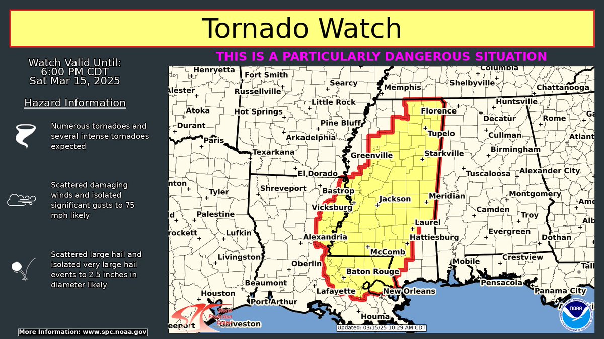
A Particularly Dangerous Situation Tornado Watch is now in effect for much of MS and northern LA until 6 pm CDT
Numerous strong long-track tornadoes are likely, along with very large hail and damaging winds
Stay weather aware for critical info see https://t.co/QMmU4tBZDt pic.twitter.com/ia5iDhhfgF
— NWS Storm Prediction Center (@NWSSPC) March 15, 2025
A Particularly Dangerous Situation Tornado Watch is Now in Effect for Much of MS and Northern LA Until 6 PM CDT
When the National Weather Service (NWS) issues a warning like this, it’s time to pay attention. A Particularly Dangerous Situation Tornado Watch signifies that conditions are ripe for severe weather, including the possibility of long-track tornadoes. This isn’t just your everyday weather alert; this is serious business. The areas affected, primarily Mississippi (MS) and northern Louisiana (LA), should stay vigilant as the clock ticks down to 6 PM CDT.
Tornado watches indicate that severe thunderstorms capable of producing tornadoes are expected or occurring in a given area. It’s important to understand that this watch covers a wide region, implying that multiple communities could be impacted. If you’re in the watch zone, you should have a plan in place and be ready to take action should a warning be issued.
Numerous Strong Long-Track Tornadoes Are Likely
What exactly does it mean when we say “numerous strong long-track tornadoes are likely”? Well, first off, the term “long-track” refers to tornadoes that can travel significant distances, often causing damage along their path for many miles. Unlike short-lived tornadoes, which might touch down and dissipate quickly, long-track tornadoes can wreak havoc over a much wider area.
In this situation, meteorologists are warning that there could be multiple tornadoes forming, each with the potential to be strong. That’s why it’s so important to take this watch seriously. Remember, tornadoes can develop rapidly, sometimes with little warning. Keep your eyes on the sky and stay updated with the latest forecasts from reliable sources like [NWS Storm Prediction Center](https://www.spc.noaa.gov).
Along with Very Large Hail and Damaging Winds
In addition to the tornado threat, this weather event is also likely to bring very large hail and damaging winds. Hailstones can reach sizes that can cause serious injury, not to mention damage to vehicles, roofs, and crops. If you’ve ever seen golf ball-sized hail, imagine that, but larger and falling from the sky with incredible force.
Damaging winds are another significant concern. Winds exceeding 60 mph can snap trees, damage power lines, and create flying debris, which poses a hazard to anyone outside. It’s essential to take these threats seriously because they can lead to life-threatening situations.
Stay Weather Aware for Critical Info
Staying informed is crucial during severe weather events. The best way to do this is by utilizing multiple sources of information. Whether you prefer weather apps, local news stations, or social media updates from trusted weather organizations like the [NWS](https://www.weather.gov), make sure you have a plan to receive timely updates.
Before the storm hits, familiarize yourself with safety practices. Know where your local shelters are, especially if you live in a mobile home or a less sturdy structure. If you’re in a tornado watch area, practice your emergency plan. Identify a safe place in your home—preferably a basement or an interior room on the lowest floor—and make sure everyone in your household knows where to go.
Understanding Tornado Watches and Warnings
It’s essential to understand the difference between a tornado watch and a tornado warning. A tornado watch means conditions are favorable for tornadoes to develop, while a tornado warning means a tornado has been spotted or indicated by radar. If a warning is issued, take immediate action. Head to your safe spot, avoid windows, and listen to emergency services for further instructions.
The importance of being prepared cannot be overstated. Familiarize yourself with the alerts in your area and have a plan in place. This way, you won’t be caught off guard when the weather turns severe.
Protecting Your Property and Loved Ones
While you can’t control the weather, there are steps you can take to protect your property and loved ones. Make sure your home is ready for severe storms by securing loose items outside that could become projectiles in high winds. If you have a storm shelter, ensure it is stocked with essential supplies like water, food, first-aid kits, and flashlights.
Additionally, consider investing in a weather radio that can provide alerts even when your power goes out. This can be a lifesaver during severe weather events, allowing you to stay informed even when other communication methods fail.
What to Do During a Tornado Watch
During a tornado watch, keep an eye on the sky and monitor the weather forecast. If you notice dark, swirling clouds or hear a loud roar that resembles a freight train, seek shelter immediately. It’s also a good idea to have a weather app on your smartphone that can send you alerts and notifications.
Stay indoors, and if you’re in a mobile home, consider relocating to a sturdier structure. Avoid windows, as flying debris can shatter glass and cause injuries. Instead, find a safe room in your home or an interior hallway where you can protect yourself from potential harm.
After the Storm: Assessing the Damage
Once the storm has passed, it’s crucial to assess the damage safely. Check for injuries among family members and neighbors, and avoid any downed power lines. If you’ve experienced significant damage, contact local emergency services for assistance. Document any damage for insurance purposes, and do not enter any buildings that may be unstable.
Stay updated with local news for information on recovery efforts and resources available for those affected. Many communities have programs in place to assist residents after severe weather events, so reach out for help if you need it.
In Summary: Stay Prepared and Stay Safe
Severe weather can strike without warning, and being prepared is your best defense. A Particularly Dangerous Situation Tornado Watch means that you should take the possibility of strong tornadoes, hail, and damaging winds seriously. Stay informed, have a safety plan in place, and make sure your loved ones know what to do in case of an emergency.
Whether you’re a seasoned weather watcher or new to severe weather alerts, it’s always wise to stay proactive. Monitor the [NWS Storm Prediction Center](https://www.spc.noaa.gov) for real-time updates and guidance, and remember that your safety is the top priority. By remaining alert and prepared, you can navigate severe weather events with confidence.